(Please excuse the lack of entries…i greatly underestimated access to Internet in NZ and how much free time I would actually have to write. Below are some entries I wrote a few weeks ago but couldn’t upload. Also in an effort to make these more frequent, i’m going to write more abridged entries on a more frequent basis.)
Rangitoto
Rangitoto is volcanic island off the coast of Auckland, accessible by ferry for $6NZD. Formed only about 600 years ago, the island is mostly void of animals and insects. Plant life is abundant but limited to ‘primordial’ species including lichen, mosses and ferns. In other words, you could lay down on the ground and spend the entire night without running the risk of getting mauled, bitten or stung by a creature. (Ok.. maybe a bird might poop on you.) The island feels ancient and young at the same time: aside from the paths and facilities built by the park conservationists, the landscape feels like a cross-bread of moonscape and tropical forest. Pyroclastic debris litters every inch of the island and giant ferns grow on any spot that isn’t covered by boulders.


I went on the morning ferry at 10am with about 9 other people. A mixed bunch of heavy-duty looking backpackers and under prepared, flip-flop wearing tourists. After the captain gingerly docked the giant high-speed ferry amidst rocking oceans, we disembarked and made our way to the welcoming center and only facility on the island. There was a general sense of unease amongst us, after the captain warned us that the last boat to leave the island was at 3:30 and there was absolutely no other means to get off the island. No emergency evac, no phone to call anyone, no running water or other facilities to make shelter with. On one hand it was refreshing to be permitted to run free and explore the island but on the other hand it was unusual that there would be no backup plan.
I consulted the island map and saw I had about 3 different trails to chose from, each about 2.5 hours one way save one. There was an express route to the summit that was only an hour but had a side trail that led to something simply labeled as ‘lava caves.’ Cool! By my calculation, i had a solid 5 hours to explore the island. I made my way up the express trail, passing other hikers along the way. This wasn’t a race but I was here to see the whole island! Make way! I found the signs to the lava caves, not knowing what to expect since none of the plaques on the island offered any explanation about them. I arrived in what seemed like a sinkhole in the forest, about the size of a camper van. I looked around to see if i had missed a turn. I scanned the depression again and then saw that in one corner there was a hole, about 2ft by 2ft big. I walked up to it and felt cold air coming out of it. This must be it! Why should I assume the lava caves would have gaping entrances? I took off my water bottle and messenger bag, lay them on the side and got down on my knees. Only, knees wasn’t enough. I had to get on my belly and snake my way into the hole. I took comfort in the fact that I knew there weren’t going to be any spiders or cave-bears that could surprise me. I fashioned the LED light on my iphone, and clawed my way into the cave which after about 4 feet of crawling, opened up into a HUGE, triangular furrow. Truly, it looked like a perfectly excavated tunnel that snaked its way into the underbelly of the mountain. Wow! Not only had I found a lava-flow tunnel, but also become Bear Grylls from the Discovery Channel. Moss hung from the ceiling, but otherwise it was perfectly barren, cold and wet. I took a few videos to prove where I was (to be uploaded at a later time) and made my way out to find a few surprised hikers that were deciding if i was brave or crazy for going in there. In retrospect, i guess it wasn’t clear if the caves were actually meant to be entered…
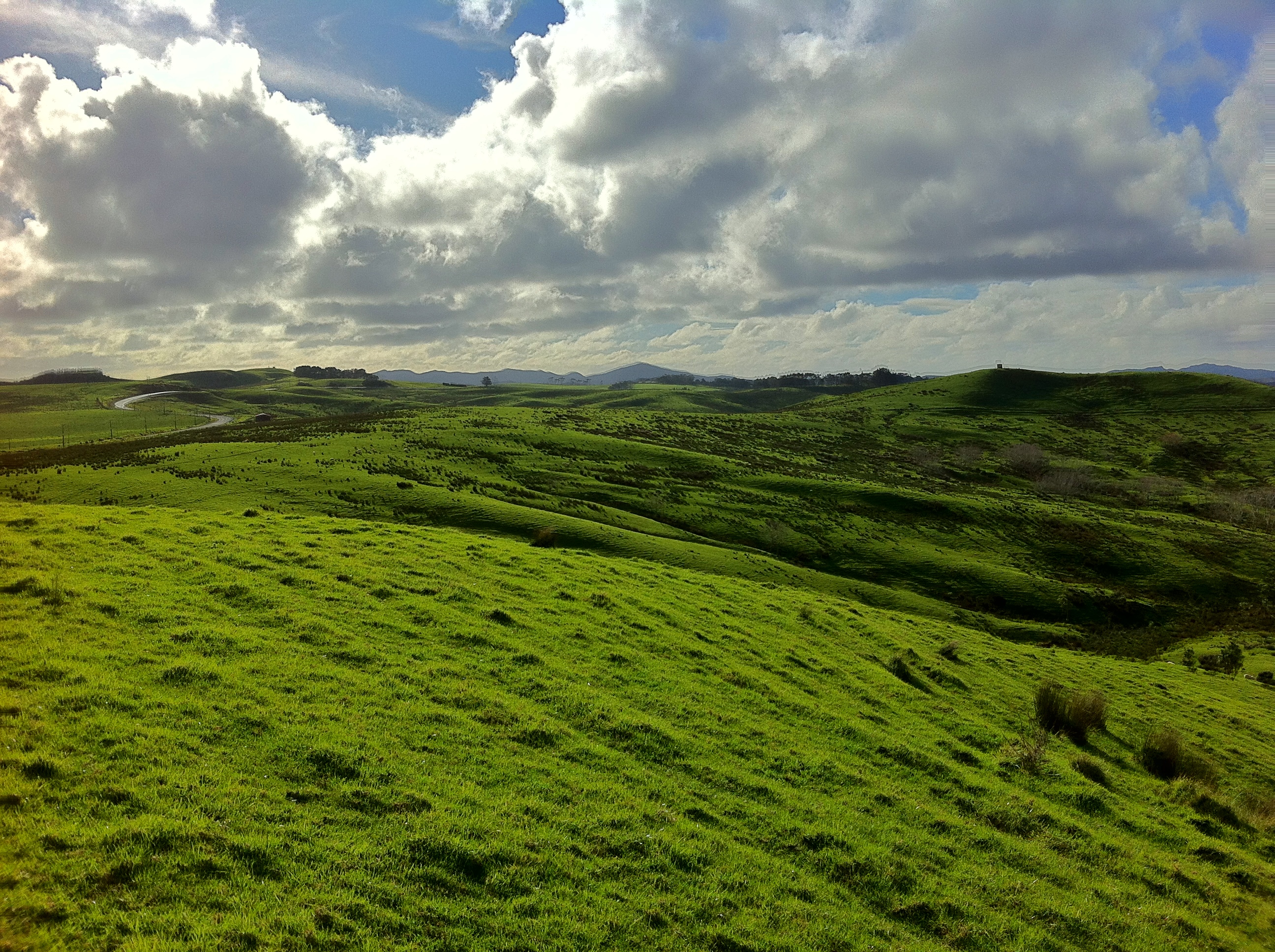
Regardless, it was done, my adrenaline was pumping and I kicked it into high gear and reached the summit in record time. Because of its location and vantage point, Rangitoto island was a key facility during WWII. At the summit lay a bunker/gun-house which had a fantastic flat room that I could climb on. The panorama I took is the main banner image you see at the top of my blog. The view was spectacular! What makes New Zealand vistas so beautiful are the endless horizons, deep blue sky’s and big billowing white clouds above the lush green landscape. There are no lazy hues…only bright, eye-popping colours.
I enjoyed a snack and started my way down the mountain. I looked at my watch and tried to decide if i could see more. Thinking about how cold the wind felt, i decided i didn’t want to risk spending the night here and made my way down towards the harbor via a different trail then i had come. Only about 1.5 hours into my walk did i realize that i should have encountered an intersection about 45 min. ago. I looked at my map and realized i had somewhere gotten on the 3 hour trail…and was heading away from the harbor. I took a swig from my water bottle and thought about what was happening. Breathe……Breathe…..Breathe……YIKES!! I booked it down the path i had arrived on until i found the intersection I had missed. I’m sure I beat my personal record for running the mile that day!
I even had a few minutes to spare when i got back to the wharf, although I could already see the ferry approaching on the horizon. I boarded the ship and collapse in a cushioned booth. I open a book on Maori folktales and thought about where the name “Rangitoto” came from. It means “Bloody Sky” after a warrior that landed there and died of a wound…or so the legend has it. He probably just missed the 3pm ferry.
Davenport
Davenport is another quaint ‘burrow’ of Auckland just across the harbor. Within 15min, you are in a small town which offers a village-like feel and many independently owned stores and restaurants. I treated myself to a cream-filled pastry at a local bakery and was glad that I did. The main attraction in town is Mt. Victoria, another small volcano that protrudes the center of town and around which everything else is built. On top of it sits another piece of WWII history, a large cannon that was able to shoot projectiles many miles. There are several other WWII landmarks on Davenport, all equally interesting to visit. Myself however was more interested in the views and parked myself on a bench at the top of Mt. Victoria to gaze down on the harbor and Auckland. I’ve found New Zealands beauty to be best consumed from higher ground from whence you can appreciate not only the expanses of green hilly pastures but also soak in the oceans and bold blue skys with its billowing white clouds, all at once. At this point in time (about 10 days into being at New Zealand) I have probably hiked to 3 dozen such vistas, and I am still awe struck each time. There’s something about being able to sample these distinct landscapes all at once that make it so special each time.

View of Davenport

Mount Victoria in Davenport

Trees in Davenport
Leaving Auckland: Whangarai, Paihia & Taipa
My friends arrived on the 11th of August and we picked up our campervan and home-to-be for the next 3 weeks, the following day.

Our van
Campervan tourism is immensly popular in NZ and there’s no need to explain why. Some travellers even suggest buying a used campervan on Craigslist if you’re off to explore the island for any length of time and to sell it back upon departure: the cost is a fraction of what it would be to see the many idyllic places using traditional tourist transport. Although there are hundreds, if not thousands of hostels in NZ, campsites are nearly as abundant. For those willing to part with overnight electricty, there are many basic campsides (aka ‘Freedom Camping’ sites) that are government owned and only require a small camping fee in exchange for an overnights parking spot. Locations of these sites are readily marked on the numerous tourist maps available at the Information Centers in every town. And just because it’s government owned, don’t think you’re comprimising on the views. We’ve freedom camped overnight on the beach, overlooking mountains and tugged away besides geothermal rivers inside beautiful forests.

Sure, Freedom Camping sites are fewer in number than for-profit campsites, but the cost is far lower as most camp sites charge per person instead of per vehicle and anywhere between 10 and 20 dollars. It should be noted that all Freedom Camping sites still have proper toilets and running water.
The campervan itself has proven to be much more spacious and practical than we first gave it credit. About the size of a standard van, there is an additional ‘bunk’ that lays atop the vehicle and offers a double size bed by night and storage for our backpacks by day. The interior boasts a mini-kitchenette with sink and running water, a fridge, a gas stove, cabin lights, a dining table, a picnic table, window shades for privacy and ample storage space for dry goods and food. It also comes with enough bedding, linens, cutlery, dishware and cookware for 4 persons so we feel well equipped. It took us a few days to fang-shui our belongings into a satisfying configuration, but when cruising down the highway with the windows open, nestled into the comforable chairs and your feet are up on the couch, watching the stunning scenery move past you, it feels more like a cozy train ride than a van. You can’t help but ask yourself why travelling shouldn’t always be this relaxed.
We spend the first several days driving north with the goal being Cape Reinga, the northern-most point of New Zealand. 20km outside of Auckland the highways, shopping plazas and gas stations melted away and gave way to more and more greenspace. We decided to drive the longer, more scenic route along the coastline and made way to Wangharai. It was dark by the time we arrived and we needed to find a place to park. Mind you we had not yet learned about freedom camping and assumed we could probably park and spend the night anywhere with our van. However, we soon encountered numerous signs strictly prohibiting any camping. Clearly, this is a common problem. Luckily we found what was marked as an “I Center” on our map. I Centers (information centers) exist in every town and are meant to help tourist navigate the towns and plan their stays. This iCenter was closed but a local woman at a nearby gasstation ensured us that we could park in the parking lot of the iCenter and spend the night but that “we should be careful because….you know…there has been trouble in the past.” It wasn’t the most comforting tip we had received but at least it meant we wouldn’t be fined. As a side note, this woman also told us that if we were hungry we should go and check out this joint called Dominos. “You ever heard of Dominos? They do pizza. It’s real nice…you’d like that.” she told us.
We skipped Dominos but parked our van in the ‘saftey’ of the darkest corner of the parking lot we could find. Setting up the beds (me on the top bunks) and the girls on the bottom bed, we prepared ourselves for the impending cold seeping through the poorly insulated doors and windows of the van. Sure we could park the car at a powered campervan site so that we could turn on our heaters but like i said above, who wants to spend $20 per person if you’re on a budget? We survived the night although we all awoke with slight doubts about the sustainability of this endeveaour: It was cold enough inside the car that we could make out our breath in the air and we had no access to hot water to wash up or warm ourselves. We boiled water and made tea and coffee and huddled under our blankets for a while longer until we felt the chill lift from our bones. After that, we reassembled the car to driving mode and continued on.
And so we travelled onwards, ever north, for the next 4 days passing through many scenic ocean side towns. We realized we weren’t covering as much ground as we’d hoped since there were so many scenic views for which we just had to stop and take pictures. Of course, no one was complaining either. Truely, not even an hour could pass without all of us ‘OOOhing’ an ‘Ahhing’ about 3 or 4 times at some other beautiful ocean cliff, or white sand beach, or rolling lush pasture or dramatic tropical vegetation. It made it difficult because we’d get to a town and decide that we’d have to stop there for the night but then we’d drive another 5km and find another such town. So we simply drove till it was dark and couldn’t be distracted by what was around us anymore.
Within a few days time, we had become quite shameless at asking locals how we could forgoe paid parking altogther. Luckily, someone always obliged. Most of the time we even got some pretty good views, save one time when we had to park/hide on a public parking lot behind a kindergarden and a firestation. Parking behind a kindergarden probably looked pretty suspicious but no one said anything and we were gone by morning.

On our way North

Whangarei Falls

Parked for the night in Paihia

At an artists studio in Whangarei
Cape Reinga
We finally made it to Cape Reinga, the northern point of New Zealand. There exists only one road to it and is about 2 hours one way. There are no towns along the way, just one gas station. It felt a bit like we were driving towards the end of the earth. We passed perhaps 6 cars along the way and stopped about 30 times to take pictures of dramatic views. We arrived at a a rather unceremonial round about with a public rest room and 20 parking spaces. Mounds of grass and dirt surrounding the parking lot so it was impossible to see what lay beyond. We exited the lot and were immediatly knocked over by the splendor of the view. All around and as far as the eye could see, ocean. Not just infront of you, but also around you. We had driven onto a peninsula and there was probably more than 270 degrees of panaromic ocean views. There was a mound and a path that led to a lighthouse, set on the tip-most part of the peninsula. The signs described how right ahead of us, only a few feet away, the Tasman and Pacific Ocean were colliding. It’s bizarre to be told that two oceans that you’ve only ever seen seperated on a map by a line, are colliding right infront of you. It’s weird to look at an imaginery border.

Flying to Cape Reinga

Panorama of Cape Reinga

View of the tip of Cape Reinga

dangling our feet off the edge enjoying some wine and waiting for the sunset

Where Oceans collide
Cape Reinga also turned out to have the best star gazing i’ve ever encountered. It didn’t even occur to us until after sunset that the lack of any man-made light for over 100km, coupled with a clear sky, that we should probably see the milky way. And true it was. The stars and the milky way were so unbelievably bright that it looked like a white cloud swashed across the sky. As the last people on Cape Reinga, we lay on the ground of the parking lot and stared at the sky for an hour until the cold wind chased us away. We found another freedom camping site and called it a night. A very starry night.
Next Up….Coromandel and the South Island…

Cathedral Cove

View of Queenstown valley

Lake Wanaka – South Island

View on our drive to Wanaka

Punakaiki – South Island

In Queenstown

Pancake Rocks at Punakaiki
….till next time